
Ellesmere Island
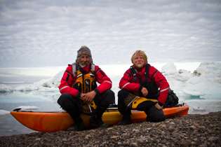
In 1988, Chris Seashore and I paddled from the south coast of Ellesmere Island, up the east coast and across to Greenland. The story of this adventure is chronicled in my first book, Cold Oceans. It’s been nagging me, for the last few decades, that no one in modern times has circumnavigated the island. (Of course some teenagers on dogsleds may have done it a long time ago, but that is a different story.) So I decided to go back to Ellesmere. But with whom? It promised to be a hard trip. Through a strange, (synchronous?) series of coincidences, I ended up -- very fortunately -- with Erik Boomer, who turned out to be an amazing partner. I couldn't have done the trip without him.
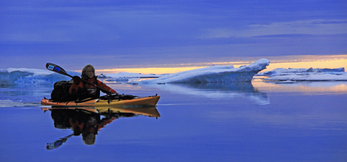
Ellesmere Island is one of the closest points of land to the North Pole. Our route followed the rugged, treacherous coast of Ellesmere for 1,500 miles. We completed it in 104 days, averaging almost 15 miles, half a marathon a day, for three months.
After completing this expedition, Boomer and I received numerous accolades, including "Top Ten Adventurers of the Year" from National Geographic, "Expedition of the Year" from Canoe and Kayak Magazine, and "First Place in Print Journalism" from the Northern Lights Literary Awards. We were featured on the front page of the New York Times. The story of this expedition now forms the central core of my new book: Crocodiles and Ice.


Camp on the Arctic Ocean
The Strategy
Ellesmere Island is one of the closest points of land to the North Pole. Regarded by many as one of the last great Arctic expeditions, this circumnavigation followed the rugged, treacherous coast of Ellesmere for 1,500 miles. We started in early May, 2011 and sailed, skied, walked, crawled, and sea kayaked during the spring and summer thaw, completing the journey in mid August.
I received this photo a year and a half after the expedition was complete. Boomer and I are camped inside the small red rectangle in the middle of the photo about 1/3 of the way up from the bottom. Photo courtesy of Justin Beckers and Christian Haas (Canadian Arctic Sea Ice Mass Balance Observatory (CASIMBO)
The Route
In the first of the two maps, Ellesmere Island shown on a world map. On the northeast corner, Ellesmere is separated from Greenland by a narrow strait, which was the crux of our expedition. The horizontal red line is the Arctic Circle. The vertical red lines compare the distance from the Arctic circle to the north coast of Ellesmere with the distance from the Arctic Circle to the south. (The computerized map is somewhat flattened).

Ellesmere Overview Map
Ellesmere Route Map
Ellesmere Island Expedition Blog
Below is my Ellesmere Island blog. Most of the posts were written by my wife, Nina, following calls from my satellite phone. This is the raw material, unedited. By now, I have woven the adventure with other themes, to create my book, Crocodiles and Ice.
Packing in Grise Fiord
May 6: Grise Fiord N76 25.05 W82 53.6
Six good weather days with highs of -5ºC and lows of -17ºC are in the forecast. Some locals sought Jon and Erik out to draw them a detailed map of just where and how far from shore they should travel to get through the jumbled ice. That information gave them a good feeling for the first week of the expedition.
May 11: Hourglass Bay
Flat ice and snowstorm
Jon and Erik are in Hourglass Bay past Cape Storm, which puts them about 75 miles into their journey. It is snowing hard, so luckily they are in a cabin that the folks in Grise Fiord had told them about. They have lost count of the number of polar bear tracks and saw a mom with her cub. The ice has been rough out in the bay, but smooth inside the fiords. Their plan is to go inland from Hell Gate as the ice gets thin before the open water of this polynya. A fall through into the 8 knot current could easily trap them under the ice. Again, this is local information from Grise Fiord, which Jon and Boomer have really appreciated.
May 18: North Wind
The north wind brought such cold, that they both had to wear everything they had including their life vests. They crossed two mountain passes on the portage around Hell Gate. It’s been over a half marathon a day (13 nautical miles) in deep snow with lots of polar bear tracks. No bears. From a cabin, Boomer had to borrow some torn and worn pieces of old boots and boot like substances. He works on his footwear every night, but it is better than having a very sore achilles tendon. They are now about 7 miles south of Goose Pt, which puts them on their hoped for schedule.
Iceberg frozen into the sea ice.
May 25: Howling Headwinds
They are making 15 miles a day despite strong headwinds. Tonight they are dug in (using their paddles) about 6 miles short of Cape May which is 60 miles, or 4 days travel to Eureka, where they will see the first people since Grise Fiord. Polar bear tracks are an everyday sight, but they have yet to see one since the mom and her cub early on. They’ve seen some polar bear kills where the seal is only 1/2 to 2/3rds eaten. If that means happy bears, then that means happy campers.
A drink from a small pool of fresh meltwater on a river delta made for a welcome change and a sign of spring.
Erik Boomer
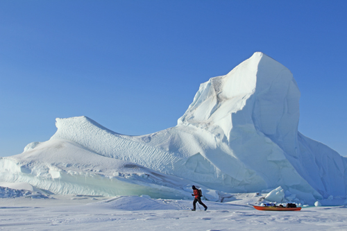
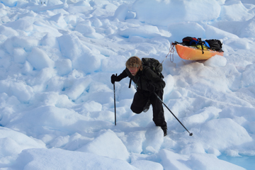
They started out pulling 220 pounds, which is heavy for the arctic. Not bad, though, for being geared for kayaking, skiing, sailing, and photography. They are feeling strong and eating well.
May 29: Eureka Weather Station
Written by Jon:
First leg of the journey. 338 nautical miles in 23 days, for an average of darn close to 15 nautical miles a day. On time , on schedule. Whew!
Greeted in Eureka by a pack of wolves, good food, showers, flush toilets, our first food drop, friendly people, our first rest day in over three weeks, and all sorts of good food to eat.
Sunny day good dragging.
Vilhjallmur Stefansson famously said that adventures only happen when mistakes are made. If no mistakes, then it’s pretty dull from the viewpoint of the outside world. Well, we’ve made mistakes. Using Boomer’s kayaking metaphor, we’ve been gnarled a bit here and there, but we’ve always rolled back up. I screwed up when I originally glued my skins on backwards, but at a hunters cabin back at Goose Point, I remounted them and glued and screwed them in place. Now I get lots of glide. Boomer has had footwear trouble, so he built some crazy boots out of bits and pieces of boot-like material he found at some of the hunter’s cabins. Those are far to the south of us now. No other civilians or civilian structures this far north. I dropped the tent and my paddle off my boat which was potentially expedition ending, but I walked back for an hour and retrieved everything. Dufus move, to be sure. Gnarled but not a swim.
Temps are warming up a lot, snow is slushy. Melt water pools and walking through deep slush at times. We expected this; it is part of the transition from Polar Spring to Polar Summer.
Coming up is the North coast, and all the uncertainties of the North Pole icepack. Emotionally, we are ready. Love to all who read this, Jon
Spirit Wolf
June 3: White Wolf
Text from Jon: N 80.48, W 88.55 Camp 28. A white wolf visited camp for 12 hours. The gate keeper of the polar regions. All’s good.
June 6: In Sight
Six inches of wet snow, slow travel but getting better every day. North coast in sight. Lots of multi-year ice. Beautiful.
Satellite view of Northwest Corner
Eddie Bauer First Ascent-sponsored Team Reaches Critical NW Corner of Ellesmere:
June 10 N81º 55′ W89º 49′
As the north wind blows over the immense Arctic Ocean, it forces broken ice into huge pressure ridges against the north coast of Ellesmere Island. This could slow Jon and Erik’s progress to less than 1/2 mile a day. In preparation for these expected conditions, they are carrying 50 days worth of food. There were a few ridges that they easily worked through, but the ice has yet to break up in earnest because it has been so cold. The ice is smooth and covered with snow. Great ski lines beckon from the 4000 ft peaks on Ellesmere. All this could suddenly change with warmer weather. (They are on the coast near the top center of this June 10 satellite photo.)
Sunny day smooth travel.
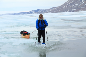
June 15: Fast Ice N82º 40′ W83º 08′
Jon’s update: “In a few miles we are at the the farthest north point of Ellesmere. We are traveling, camping and living on sea ice. To the south is a range of mountain peaks ranging from 3,000, – 6,000 ft, heavily glaciated with many of the glaciers reaching to the sea. We are traveling on fast ice. Fast ice is stuck fast to land. This is one year ice that forms in September and October and will melt soon. There is snow on this ice from 1/2” to drifts of 6’ deep. With warmer temperatures this snow becomes more slushy by the day.
As fast ice expands and contracts in winter, it pushes up into pressure ridges. Boomer writes, “Imagine a rough sea frozen in place.”
Five miles to our left, out into the Arctic Ocean, multi year ice crashes and melts partially, but never melts completely like fast ice. When fast ice forms in the fall there is potential for multi year ice to freeze into the matrix of the fast ice. Many people have told us this combination of slush, fast ice, pressure ridges and multi year polar ice can form a nearly impenetrable barrier. We hear stories of men having to take off their skis and manhandle one boat and then go back for the second, making less than a mile a day. This has not happened to us. YET. Today there were all kinds of obstacles, but we never had to remove our skis or use both of us to maneuver one boat. With lots of flat ice in between, we made 13.3 nautical miles today.
Our bodies are fine. Boomer broke a ski and is hobbling along on 1 1/2 skis, but is still very strong. Both of my skis are cracked. We don’t know what ice will come, but we are prepared for the worst and are in good spirits.”
At the food cache.
Eddie Bauer First Ascent-sponsored Team Reaches Halfway Point and Retrieves Critical Food Cache
June 22: N83º 05′ W72º 39′
Thanks to Kenn Borek Airlines, Aziz at South Camp Inn and the Catlin Group for the May delivery of this cache. We had no problem finding the food, so now the boats are loaded with 55 days worth. The heaviest they have ever been and we are still pulling.
Slush walk.
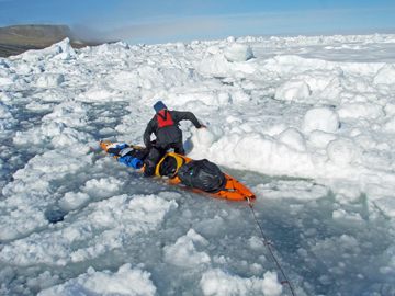
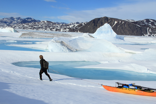
June 29: Slush and Crawl N82 52 W64 27
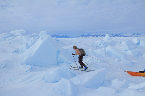
Skis no longer work in the present conditions. Since leaving Grise Fiord in early May, 822 miles ago, the surface was relatively smooth because drifted snow filled in the pressure ridges of the fast ice, leaving some larger peaks exposed like captured icebergs.
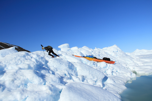
Now the warm temperatures have melted the drifted snow into pools of slush and water, some ankle deep and others waist deep on top of ice. If a melt-water pool is deep enough, sitting in the cockpit and pushing along with the ski poles works, and if it is deeper still, we can paddle. When climbing a pressure ridge, sometimes the only way to get traction in the snow drift now gone to slush, is to crawl (and totally embrace the crawl) to haul the kayaks until firmer footing is felt, then stand and walk.
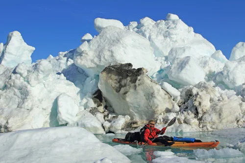
Approaching the critical northeast corner.
Huge chunks of ice 20 to 30 feet high are crammed against the shore, making it impossible to return to land. Fortunately, in some places, the melting snow feeds streams that, in turn, melt sea ice near shore. These are not true leads, but make for good traveling interrupted by ice that has avalanched or piled higher onto shore. They may only be inches deep and a paddles width, or 50 yards wide.
Today there was 2 or 3 miles of dead flat with no ridges, a relief from the norm. With all these varying conditions, we averaged 10 miles a day this week. We are neither stressed nor surprised, this is break up and it is exciting to be in it. A big change may come tomorrow, because as we turn south in 5 or 6 miles, there are many large rivers draining a big ice cap onto low lying land. Hopefully this will create huge shoreline melt-water pools, but we may be wrong.
664 miles to go and we are loving the trip.
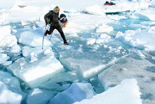
Jumping across tippy floes.
July 5 : On the Move
A flurry of texts:
Jon and Erik – ice opening rapidly (then later) ICE CHANGING EVERY HOUR VERY EXCITING MAYBE PADDLING CLOSE TO SHORE TOMORROW!
Trudy – Looks like the ice in Robeson is on the move
“NE wind keeps ice tight & near Ellesmere, clears Greenland waters. Ice drifts SW. Contrary wind slows drift, opens pack. 2kt (knot) drift on floes near Elles good choice?” Dr Humphrey Melling Research Scientist – Fisheries and Oceans Canada Institute of Ocean Sciences .
Not moving
July 6: Not
The ice foot along the shore is rotted out, gritty and undercut. Just out from there are jumbled chunks of ice, refrigerator size and smaller, all crammed together, but they roll and tip, and the huge pressure ridges have not broken apart. So they are still in Monday’s camp, a nice mossy flat bench on the shore and next to a river. The coast guard flew over and tipped their wings. Both Jon and Erik are in total agreement to wait for the ice pack to loosen.
Impenetrable ice
July 12: The Squeeze N 82 23 W 61 11
As Ellesmere explorer, photographer and author Jerry Kobalenko said “But the real test will come when they turn the corner after Alert and meet the pack ice that flushes down from the Arctic Ocean.” http://jerrykobalenko.com/ellesmere.htm

Camped on an ice floe.
Jon and Erik have gone all of 2 miles in the last 6 days as they approach The Nares Strait, which forms a bottleneck for the southern flow of ice. The imperfect mix of rubble ice, varying from baseball to tent size, is too unstable to walk on (picture a martini with floating marbles), and too dense to paddle through. They are hoping for more of the forecasted larger flat pans of multi-year ice, of which there is now maybe one a day, but is out beyond the impenetrable rubble. Since the shoreline becomes a series of 3000’ cliffs for 55 miles with a rotten ice foot, the only other option is for a strong and sustained SW wind to move all the pack off the Ellesmere shoreline, but in the narrow Nares Strait, there is less wiggle room for this. They would need open water to only be wide enough to paddle a kayak, but guaranteed not to close them into the cliffs.
With the wonderful help of two Canadian ice scientists, Trudy Wohleben and Humfrey Melling, they are weighing these options.
July 13: Adrift On 5 Acres of Ice N 82 22.8 W 61 08.5
Three techniques and three hours to make 300 feet through the rubble, Erik and Jon have landed on a 5 acre multiyear ice floe. Paddling out was impossible, so they jumped from one tippy chunk to another with a rope to pull the boat, or they used the boats as a bridge or Boomer would jump and they would pull the two chunks together. The floe they are on is 6 feet above the sea level. Their camp is behind a pressure ridge on firm ice near a melt water pool. When they called, it was the beginning of the flood tide which was pushing them toward Black Cape at 4/10 of a knot. The full moon tides are strong, and although this floe is not huge, it is thick with the extra 15 feet of pressure ridge, so they feel solid for now. They used up the 3 hours of slack tide (in flood tide things are moving too much) getting this far out, so tomorrow they intend to hop out to bigger floes during slack and a part of ebb tide. Plans will be made depending on where the pan takes them. They’re enjoying this.
July 14: Back on Land N 82 24.3 W 61 14
After sleeping for most the night while heading south on the little floe, the water opened up and then everything reversed direction and started to pack in tight. Jon and Erik ran around on their little mountain range to watch the spectacular show. Although they had drifted further from land (and further north) they made fast time back to shore. The ice is now packed very tight. They still have all their gear and food for a month, are feeling strong and fit, so tomorrow they will make their way south during high tide.
When the shore lead runs out.
July 18: Tides N 82 15.7 W 61 07.3
Tides rule the ice near Cape Union. Erik Boomer and Jon Turk have taken footage as 6 foot thick sections of ice collide with land and explode into standing 30 foot walls. The watery world races south in flood tide and rips north in the ebb. Deeper bergs will ground themselves and create a channel of protection which allow them to paddle in blue water from 3 to a hundred feet wide. The shore is mostly cliffs, so during the flood tide they paddle or pull over avalanche debris and a rotten ice foot until reaching a safe shoreline above high water, then judge the time and distance to the next safe bivouac. Three days ago, it was mostly steep shale talus in which they had to unload the boats and ferry the loads in thirds. That was a 1.1 mile day. Yesterday was more of a mix of ice and water, so they made 2.5 miles. Today they were gifted with more paddling and they gained 3.5 southern miles. Then the tide began to turn with four miles of cliffs ahead. Tides and time do not wait, so they are.
In the bottleneck.
July 22: Busting Out
Yesterday, the rubble ice churning with the tide along the cliff face forced them to retreat once again. For three weeks they have been stalled out in this area as ice from the Arctic funnels into the narrows of The Nares Strait. They hoped to get a second chance with the next flood tide, and I awoke to the following text:
“Busted out of hang camp in heavy rubble ice. in Lincoln bay at 4AM” Finally, a 15 mile paddle!
Green arrow points to Lincoln Bay. Red arrow points to Cape Union above which they were stalled for three weeks. This shows that the Nares Strait catches the ice as it comes south between Ellesmere and Greenland. You can see how the ice further south has opened up.
Slow paddling.
July 25: Hikers
While sitting on their kayaks on top of a 20 ft chunk of ice, Erik and Jon were totally surprised to see some hikers. They were Quttinirpaaq Park rangers out from Ft. Conger. A fortunate meeting because Jon and Erik had not been near shore much the last two days, and the (“Top of the World Park”) rangers were heading out on their patrol.
Strong NE winds blew huge ice into The Nares Strait last Friday, so they spent that day watching the powerful show. Yesterday they had excitement hopping and riding pans for eight miles. Today, Monday, it was calm enough to pan hop across St Patrick Bay and go along the ice foot on shore. They are now in Hall Basin, which gives more room for the Arctic ice funneling down through the narrow Nares Strait. July has been arduously slow, but they feel confident in making to to Grise Fiord before the storms kick up the seas and bring snow squalls in early September.
Daiquiri ice
July 27: Speed Limit
It was a twelve hour day to cross the 12 miles of 95% ice in Lady Franklin Bay. Once again, Erik and Jon”s techniques were to jump from one tippy ice chunk to another, then drag the boats over, sometimes hopping 2 or 3 before being stable enough to pull the boats. Sometimes paddling a small pan closer to another, sometimes seal launching across, and every once in a while they were able to paddle a narrow lead that was going their way. Winds were low, so in the large mouth of this bay which is open to all the incoming polar ice, this mix of ice was calm. Time is getting short, they need a month of 20 mile days. To use Andrew Garcia’s title of his wonderful book, this is a “Tough Trip Through Paradise.”
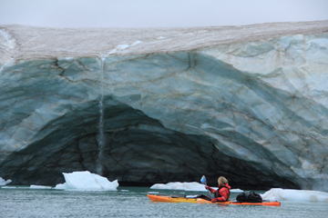
More or less open water.
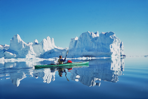
August 4: Making Miles N 79 40 W 72 07
Jon and Erik are finding that the ice is much more dispersed, and they have averaged 18 miles a day for the past four days.
August 10 & 12: Winds for Home
This is late because lightening took out my internet. On the 10th Jon and Erik were nearly equal longitude and latitude: N77º 47’, W77º 45’. Another landmark was their passing of Cape Herschel. Jon and his extraordinary wife and expedition partner at the time, Chris Seashore, had kayaked to here in June 1988 from Grise Fiord and crossed over to Greenland as told in the book “Cold Oceans”. Time and circumstance had brought many changes, including the astonishing retreat of the glaciers along this coast.
If luck holds the wind forecast for today, the 13th, then it will be downwind for their final 6 days of this 103 day journey.
Bad boy polar bear.
August 14: Ice
Ok, so it is my wishful thinking that the winds were favorable, but not so when mixed with ice. Text from the guys: “Bears scare us. We scare bears. Wind scares us. We do not scare wind.” The wind should ease off by Tuesday the 16th.
August 15: Counting
Text: “Bad boy bear bites hole in tent while we sleep and 5 of his buddies watch” 81 miles from Grise Fiord, maybe 4 days.
Torn tent and the culprit.
August 17: Tomorrow-Last Push?
The wind was howling off the ice cap as Erik and Jon made their way around King Edward Pt. to (abandoned) Craig Harbor. A hunter’s cabin here shelters them as they dry off and warm up. Jon couldn’t talk to me for very long because he was standing out in the wind in his underwear. Tomorrow should be their last push for Grise Fiord, which is over 35 miles away, across the open water and ice of a wide bay. They will have 10 knot winds against them.
Expedition completed.
August 19: They Made It
Boomer and Jon made it to Grise Fiord at midday. Jon can hardly walk and Boomer’s feet are swollen two sizes, but they were always in great spirits despite over 100 days of being wet, salty, and cold.
Thanks to everyone who helped and everyone who followed this blog.
Eddie Bauer First Ascent-sponsored Team Completes First Circumnavigation of Ellesmere Island
Erik Boomer and Jon Turk traveled 1485 statute miles in 104 days, skiing on rigid fast ice, jumping from flow to flow on moving pack ice and finally paddling through ice choked water.
They would like to thank the following: Eddie Bauer First Ascent, Polartec, Wilderness Systems, AT Paddles, Kokatat Paddling Gear, WindPaddle Sails, 40 Below Overboots, NRS Watershed Dry Bags, and Iridium Communications. All the gear withstood the harshest polar conditions and made this expedition possible.
Back Home
Jon, here, writing the last post:
Thirty-nine hours after successfully arriving in Grise Fiord, I awoke in the middle of the night with the fearful sensation that my metabolic systems had broken down. Friends drove me to the local medical clinic, where my condition was considered “life threatening.” I was medi-vac’ed to Ottawa by Global Rescue, an amazing outfit that stepped up to the plate when my life was on the line. After 6 days in hospitals and medical clinics, I returned home to the real beginning, here in my home in the forest in Montana, which I share with my wonderful wife, Nina.
Global Rescue Air Ambulance
Not dead yet.
Thank You To Our Sponsors
Eddie Bauer – First Ascent; Polartec Performance Grant; Wilderness Systems and AT Paddles
